EL NIÑO CONTINUING TO BUILD UP
2023-10-13
As informed by the National Oceanic and Atmospheric Administration (NOAA), NOAA's National Weather Service of the USA, El Niño is expected to continue through the Northern Hemisphere spring -with an 80% chance during March-May 2024-.
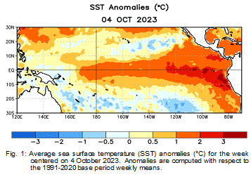
In September, equatorial sea surface temperatures (SSTs) were above average -Fig. 1-, though positive anomalies weakened in the eastern Pacific. All of the latest weekly Niño index values remained in excess of +1.0ºC: Niño-4 was +1.2ºC, Niño-3.4 was +1.5ºC, Niño-3 was +1.9ºC, and Niño1+2 was +2.6ºC. Area-averaged subsurface temperatures anomalies decreased but remained above average, consistent with elevated subsurface temperatures across the central and eastern equatorial Pacific Ocean. Tropical atmospheric anomalies were consistent with El Niño. In areas of the central Pacific, low-level winds were anomalously westerly, while upper-level winds were anomalously easterly. Convection was enhanced around the International Date Line, stretching into the eastern Pacific, just north of the equator. Convection was suppressed near Indonesia. The equatorial Southern Oscillation Index (SOI) and the traditional station-based SOI were both significantly negative. Collectively, the coupled ocean-atmosphere system reflected El Niño.
The most recent IRI plume favors El Niño to continue through the Northern Hemisphere spring 2024. Also, considering recent observations and the NMME, the team favours at least a "strong" event with a 75-85% chance through November-January (³1.5°C for the seasonal average in Niño-3.4). There is a 3 in 10 chance of a "historically strong" event that rivals 2015-16 and 1997-98 (seasonal average ³ 2.0°C). Stronger El Niño events increase the likelihood of El Niño-related climate anomalies but do not necessarily equate to strong impacts locally.